
Genesis, morphometric and hydrological features of lake Sinyavskoye in the Volodarsk municipal district of the Nizhny Novgorod region
Abstract
The article presents the results of a bathymetric survey of Lake Sinyavskoye, carried out as part of the limnological research program of the Nizhny Novgorod Regional Branch of the Russian Geographical Society. For the first time, data on the depths and relief of the bottom of Lake Sinyavskoye have been obtained and analyzed. The physicо-geographical characteristics of the lake's surroundings have been performed. Based on field research materials, a digital bathymetric map of the lake has been built using modern geoinformation systems. The main morphometric and hydrological parameters of Lake Sinyavskoye have been established. In the course of a comprehensive analysis of the results of bathymetric surveys, thematic maps, hydrological and morphometric characteristics and landscape features of the territory, surrounding the lake, the genesis of the lake basin was determined. It has been established that Lake Sinyavskoye has a karst origin, which is confirmed by a complex of specific geological and geomorphological features. The results of the research were processed using the QuantumGIS geoinformation system, which made it possible to effectively integrate, analyze and visualize spatial data. The use of GIS has ensured high accuracy of spatial analysis, the identification of patterns and relationships between geographical objects, and simplified the interpretation of the results through a visual cartographic representation. The results of the conducted research may be of interest to specialized specialists, scientists, students of natural science specialties, environmental organizations and local authorities.
References
Zieliński A. Morphometric characteristics of the karst Jasne lake and the little unnamed lake in the area of the Golejowskie Forest near Staszów. Contemporary reasearch problems of Polish geographical studies – physical geography. Geographical Records. 2008, no. 37, pp. 56-61.
Yunginger R. et al. Morphometric characteristics of Lake Limboto as critical lake in Gorontalo Province, Indonesia // Jurnal Natural. 2024. Vol. 24, no. 2, pp. 99-106.
Dmitriyev P. S. et al. Use of geoinformation technologies in the study of cartometric and morphometric characteristics of lakes in the North Kazakhstan //InterCarto, InterGIS. 2022. Vol. 28. pp. 719-736.
Pi X. et al. Mapping global lake dynamics reveals the emerging roles of small lakes //Nature communications. 2022. Vol. 13. no. 1. pp. 5777.
Ren H. et al. Response of dissolved organic matter (DOM) and microbial community to submerged macrophytes restoration in lakes: a review //Environmental Research. 2023. Vol. 231. pp. 116185.
Геологическая карта и карта полезных ископаемых дочетвертичных образований: O-38-XXXI. Геологическая карта СССР. Геологическая карта четвертичных и дочетвертичных образований и полезных ископаемых. Мезенская серия, масштаб: 1:200000, серия: Мезенская. [Электронный ресурс] - Режим доступа: https://www.geokniga.org/maps/41023 (Дата обращения: 12.11.24).
Карта четвертичных отложений: O-38-XXXI. Геологическая карта четвертичных отложений, масштаб: 1:200 000, составлена: Средне-Волжское геологическое управление, 1979 г., авторы: С.В, Алехин, О.Н. Шаталова; редактор: Т.Е. Горбаткина [Электронный ресурс]. URL: http://www.geolkarta.ru/list_200.php?idlist=O-38-XXXI&idlist_d=Q&gen=1&g=1 (дата обращения: 05.04.2022).
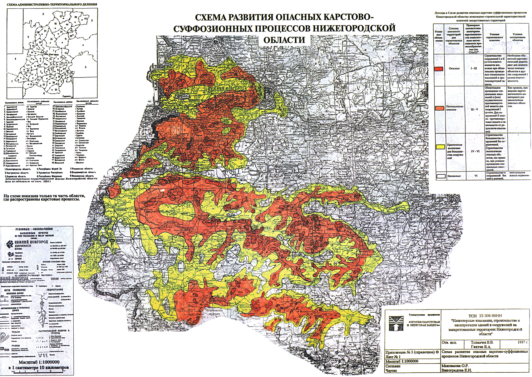
Схема развития опасных карстово-суффозионных процессов Нижегородской области, масштаб: 1: 1 000 000, отв. исп.: Толмачев В.В., Гантов В.А., составил: Максимова О.Р., чертил: Виноградова Е.Н. [Электронный ресурс]. URL: https://law.rufox.ru/images/8563/42FDC285D082B5B8BF8F4028CD38FAF6.gif (дата обращения: 15.09.2022).
Асташин А.Е. Морфометрические и гидрологические характеристики озера Инженерное Володарского района Нижегородской области / А.Е. Асташин, А.А. Огурцов, О.Е. Ватина Т.С. Нефедова, В.М. Подковырина // Проблемы экологии Волжского бассейна: Труды 9-й всероссийской научной конференции, Нижний Новгород, 03–04 декабря 2024 года. – Нижний Новгород: Волжский государственный университет водного транспорта, 2024. – С. 24.
Асташин А.Е. Озёра Большое Мартышево и Малое Мартышево Володарского района Нижегородской области: морфометрические и гидрологические характеристики / А.Е. Асташин, О.Е. Ватина, М.Н. Пашкин, О.Н. Пашкин, М.А. Дудина, М.М. Бадьин // Орфановские чтения – 2020: сборник статей по материалам Всероссийской научно-практической конференции, Нижний Новгород, 17 декабря 2020 года / Нижегородский государственный педагогический университет им. К. Минина. – Нижний Новгород: федеральное государственное бюджетное образовательное учреждение высшего образования "Нижегородский государственный педагогический университет имени Козьмы Минина". – 2021. – С. 37-43.
Романов В.А. Почвенная карта Горьковской области / Романов В.А., Сунцов. Н.А., Перевозкин В.С. // масштаб 1:400000, составлена по материалам: «Волгогипрозем». – 1978 г.
Баканина Ф.М. Ландшафтное районирование Нижегородской области как основа рационального природопользования / Ф.М. Баканина, А.В. Пожаров, А.А. Юртаев // Великие реки 2003: генеральные доклады, тезисы докладов Международного конгресса. Н. Новгород: ЮНЕСКО. – 2003. – С. 288-290.
Astashin A., Pashkin M., Badin M., Pashkin O., Vatina O., Podkovyrina V., Nefedova T. Morphometric features and genesis of the lake basins of the natural monument "Lakes Svetlye, Lake Elovoe and the surrounding swampy massif" of the Oka-Volga interfluve within the Nizhny Novgorod region // Pakistan Journal of Life and Social Sciences. 2025. Vol. 23. no. 2. pp. 1063-1073.
Copyright (c) 2026 Russian Journal of Water Transport

This work is licensed under a Creative Commons Attribution 4.0 International License.
